Eleventh District City(11th) Council Boundary Map -2011 William Cole's District - Baltimore, Maryland
View Baltimore 11ths District Boundary Map 2011 in Google Maps
3 weeks ago I was walking around the 700 block of Dolphin Street where I met upon some friends who lived there. I asked them who their council representative was and they didn't know. I thought, smugly, I bet they don't have that extra-enthusiastic council representation that I have in that Bill Cole. But then I was having a spirited email discussion tonight with Bill about those wayward city police officers and I mentioned the screaming high homicide rate on Dolphin Street, and Bill informed me that Dolphin Street IS his district. I am wondering how often he gets over there to give those West Baltimore citizens adequate city council representation. Perhaps he gets lost or distracted when he tries to visit those West Baltimore neighborhoods.
I wanted to know more about Bill's new city council district boundaries so I visited Bill Cole's personal website and took a good hard look at that boundary map in the pdf. I found the map highly substandard because I was confused as to which streets it encompassed so I decided to redraw the map using Google Maps, this way the user can choose map view or satellite view, and can also zoom in to see their home. I can only assume Bill cherry-picked where he wanted his district, notice that like jig and jog to include Shot Tower Park where there is the Police Memorial, and that strangely odd corner to include the Hanover Street boat ramp and the Viet Nam War Memorial. Bill knows that whitey loves those memorial parks. If Bill likes memorial parks so much maybe we can get a new one for all the innocent people killed by Baltimore City Police Officers. The boundary nicely abuts the prisons but he was savvy enough not to include them. Bill probably thinks prisons are so yucky and so black.
If you want to see 2 really neat maps of the same council district you may go to the City That Breeds blogpost that shows the same boundaries annotating racial make-up of the neighborhoods and income levels with data from the 2010 Census.
Except for those low-income African Americans over on Dolphin Street and Pennsylvania Avenue, Bill's new boundaries encompass a lot of Caucasians and a lot of money. I'm not sure Bill gives are rat's ass about Dolphin Street or the homicide rate. Caucasian Bill doesn't need Dolphin Street and Pennsylvania Avenue to be elected by a bunch of rich Caucasians with money. It's April of 2011 and Bill's area of West Baltimore has turned into a blood bath. He stays strangely silent on the matter of the homicides, other then when there is a vote to throw more money at the corrupt police department.
Either way, if you want to phone Bill Cole, you can call him at his council office 410 396 4816 or email him at william.cole@baltimorecity.gov . I suggest you do it frequently, those are your tax dollars that pay his city council salary.
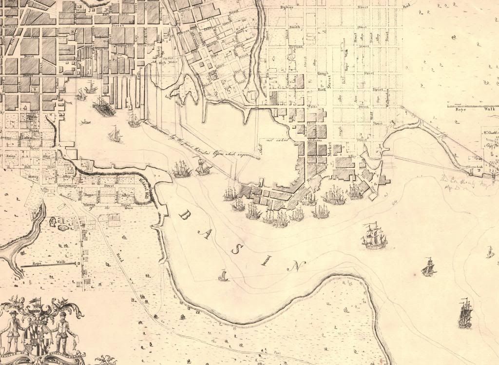
Historic Maps of Baltimore Harbor 1792-1895
I'm doing a project involving the history of the Baltimore Harbor. I've had to make up some maps to help with the project. I thought I would post them here in case anyone else needs to use them. I have an additional post that includes the harbor maps from 1900-1943. These maps are cut from larger city maps in the Sheridan Collection of the Peabody Library.
1792 Folies Map of Baltimore, harbor area only. This is the only map the doesn't come from the Sheridan Collection. You can find this at the Library of Congress or here.
1838 Boynton Map of Baltimore Harbor

1853 Water Commission Map, I like this one so much I put all of it up here, it has Baltimore City and some of Baltimore County

1855 Colton Map

1859 Weishampell Map

1895 Weishampell Map

1792 Folies Map of Baltimore, harbor area only. This is the only map the doesn't come from the Sheridan Collection. You can find this at the Library of Congress or here.
1838 Boynton Map of Baltimore Harbor
1853 Water Commission Map, I like this one so much I put all of it up here, it has Baltimore City and some of Baltimore County
1855 Colton Map
1859 Weishampell Map
1895 Weishampell Map
Subscribe to:
Posts (Atom)