
Since 1946 79 Bodies have been found in Leakin Park. Below is a map of where the 68 of those bodies were found.
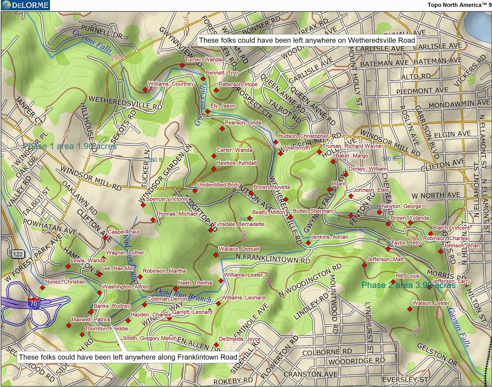
I want to make one additional comment. Anyone that knows me is aware of my attention to detail when it comes to map symbol placement. Due to the large numbers of symbols and making the map clear, and also the pathetic way the Baltimore City Police Department annotates crime scene locations, I want to admit the body placement is approximate and not exact. If you have any questions, email me. You can find the address in my profile. This list was most recently updated on 06/18/2017.
| Name | Address body was found | Date Found | Age | Murdered By: | ||
| Richard Wayne Truman (with introduction) | Mt. Holly Road area | November 18, 1946 | 13 | Robert Clayton Wright | ||
| Larry Jefferson | 3800 Stokes Drive | April 19, 1968 | 9 | Reginald Vernon Oates | ||
| Matt Jefferson | 3800 Stokes Drive | April 19, 1968 | 5 | Reginald Vernon Oates | ||
| Louis Robert Hill | 3800 Stokes Drive | April 19, 1968 | 10 | Reginald Vernon Oates | ||
| Lester Watson | 3800 Stokes Drive | April 19, 1968 | 10 | Reginald Vernon Oates | ||
| Elsie Josephine Johnson | 3900 Chesholm Road | May 28, 1969 | 16 | Andre Van Lear Foster | ||
| Eugene Leroy Anderson | r4100 Stokes Drive | killed July 11, 1969 found October 27, 1969 | 20 | Either the Black Panthers or the FBI depending on your POV | ||
| George Douglas Newton | 3700 Winterbourne Road | June 6, 1971 | 23 | |||
| Milton Beatty | 4500 Hutton Ave | March 8, 1972 | 24 | |||
| Sherman Mack Butler | Hutton Ave and Wetheredsville Road | January 6, 1973 | 20 | |||
| Thelma Nash | 4800 Franklintown Road | January 28, 1973 | 19 | David L. Morris | ||
| Wanda M. Lewis | 1400 Franklintown Road | May 18, 1974 | 15 | |||
| Alfred Washington | 1400 Franklintown Road | May 18, 1974 | 17 | |||
| William Braxton | Leakin Park | July 30, 1974 | 26 | |||
| William Emerson Dorsey | 3800 Chesholm Road | August 6, 1974 | 17 | |||
| Luther Wagner | 4800 Franklintown Road | December 2, 1974 | 21 | Fred T. Sampson | ||
| Wanda Carter | Windsor Mill Road | December 7, 1976 | 22 | Olivia L Tatum | ||
| Gwendolyn Moore | 3500 Gelston Drive | March 29, 1979 | 23 | |||
| Lester Williams | 1400 Franklintown Road | October 9, 1979 | 25 | |||
| Margaret L Robinson | 4700 Franklintown Road | June 26, 1981 | 19 | Killed by husband | ||
| Joyce Ann DeShields | 4300 Seminole Avenue | May 9, 1982 | 26 | killed by serial killer who remains on the loose | ||
| Paul John Casper | 4800 Clifton Ave | January 5, 1984 | 36 | |||
| Oliver Wendell Munson | Potentially Leakin Park | February 13, 1984 | 39 | Dennis Watson is a person of interest | ||
| Unidentified Man | Wetheredsville Road | March 19, 1986 | ||||
| Jason Ely | 4500 Wetheredsville Road | January 1, 1988 | 21 | Willy Petty Jr, Jimmie McKoy, JoAnn Petty | ||
| Hope Sarah Patterson | 1900 Wetheredsville Road | September 13, 1990 | 35 | Ronald Ludd and Richard Tirrell Cook charged | ||
| Troy Leroy Bennett | 4600 Wetheredsville Road | May 16, 1991 | 20 | |||
| Infant | Franklintown Road and Chesholme Road | November 13, 1991 | less than 1 | |||
| Timothy Washington | Most likely Leakin Park | September 11, 1992 | 8 | Keith M. Garrett | ||
| Linda Pearson | 4700 Wetheredsville Road | March 28, 1993 | 31 | Don Anthony Pearson | ||
| Unidentified Man - Suicide | 4900 Windsor Mill Road | April 17, 1994 | ||||
| Patrick Maxwell | 4700 Franklintown Road | May 2, 1994 | 27 | |||
| Bernadette Tyndale | 2000 Ridgetop Road | June 15, 1994 | 30 | Ernest Tyndale | ||
| Shante Harris | Franklintown Road | July 29, 1994 | 3 | Darntrell Griffin, Eric Duane Dorsey | ||
| Gregory Melvin Smith | 4700 Franklintown Road | May 4, 1995 | 25 | Robert Malcolm McLain Jr. aka Darryl Anthony Harris McLain or Darryl McLain DOB 05091968 No longer incarcerated | ||
| Russell Fletcher | 3700 Franklintown Road | February 1, 1996 | 37 | |||
| Renita Wallace | 1900 Ridgetop road | April 3, 1996 | 33 | Walter Percy Holmes Jr. | ||
| Courtney Williams | 4500 Wetheredsville Road | April 7, 1996 | 27 | The Dirty Cop accused Chris Black | ||
| Unidentified Man | 4500 Wetheredsville Road | April 8, 1996 | No obvious signs of foul play | |||
| Aaron Glenn | 5000 Franklintown Road | April 20, 1996 | 20s | |||
| Charles Augustus Robinson | 3500 Winterbourne Road | April 24, 1996 | 61 | |||
| Charles Hayden(found with D. Coleman) | 4800 Franklintown Road | July 18, 1996 | 22 | |||
| Deron Coleman | 4800 Franklintown Road | July 18, 1996 | 24 | |||
| Alphonso Spencer | 4500 Franklintown Road | April 27, 1996 | 37 | Allegedly Arnold Braxton Jr. and Nathaniel Powell | ||
| Rodney Alonzo Banks | 5100 Franklintown Road | May 19, 1997 | 31 | |||
| Devon Dexter Denton | 3600 Winterbourne Road | May 25, 1997 | 18 | |||
| Victonio Guy Spencer | 1900 Eagle Drive | June 1, 1997 | 26 | All charges dropped against Keith D. McCallum | ||
| Leonard Williams | 2000 Franklintown Road | July 2, 1997 | 25 | |||
| Unidentified Man | 4800 Franklintown Road | September 08, 1997 | ||||
| Wanda Turner | 3100 Wetheredsville Road | January 23, 1998 | 26 | |||
| Todd Roney | Hutton Ave and Wetheredsville Road | September 7, 1998 | 33 | |||
| Rasheed Alea Harris | Leakin Park Ravine | February 22, 1998 | 19 | |||
| Kendall Hawks | 4700 Windsor Mill Road | October 4, 1998 | 18 | |||
| Rufus Washington | 4000 Clifton Avenue | November 13, 1998 | 41 | Michael J Stewart and Antonio A Warrington | ||
| Vincent Blatch | 3500 Winterbourne Road | November 24, 1998 | 35 | |||
| Novella Peaches Brown | 4500 Hutton Ave | December 28, 1998 | 41 | |||
| Hae Min Lee | 4400 Franklintown Road | February 9, 1999 | 17 | Adnan Musud Syed | ||
| Terrance Granger | 3700 Franklintown Road | October 8, 1999 | 22 | |||
| Unidentified Man | Franklintown and Wetherdsville Roads | August 09, 2000 | ||||
| Brian Anthony Johnson | 3400 Winterbourne Road | June 10, 2001 | 18 | Eric Von Poole (although there are some questions regarding his conviction), Charles Antonio Ham, Carl Douglass Harrison | ||
| Christopher Hudson | 4500 Windsor Mill Road | June 29, 2001 | 20 | |||
| Adrian Anthony Jenkins | Franklintown and Wetheredsville Roads | December 9, 2001 | 21 | |||
| Broderick Richardson | Franklintown Road | January 24, 2003 | 38 | |||
| Carlos Herrea | Leakin Park | January 31, 2004 | 63 | |||
| Margo Baker | 4000 Clifton Ave | May 6, 2005 | 52 | Ross Telp (her son) | ||
| Stephen Robinson | 3200 Franklintown Road | October 9, 2005 | 55 | |||
| Christian Nunez | 4800 Franklintown Road | July 18, 2006 | 38 | |||
| Leonard Nathaniel Garrett | 800 Winans Way | October 7, 2006 | 24 | |||
| Freddie Thornton | 4300 Franklintown Road | December 23, 2006 | 69 | Timothy Izzard | ||
| Riley Pettus | 1300 North Woodington Road | June 7, 2007 | 43 | |||
| Kwame Saka Osafo | 3900 Winterbourne Road | October 10, 2007 | 21 | Andre Cox, Gregory Lee charged then nolle prosequied | ||
| Yolanda Brown | 3600 Winterbourne Road | March 20, 2008 | 36 | William Vincent Brown is a suspect, he was found guilty of attempted murder of another woman in Leakin Park,and pleaded guilty to the murder of 2 women in other locations | ||
| Petro Taylor | 3000 Franklintown Road | December 30, 2008 | 20 | Grechauna Rogers, Sierra Pyles, Tenisha Lawson, Anthony O. Williams, Devin Melton, Lawrence Walker, Dominique Boone | ||
| Lemuel Wallace | 3200 Franklintown Road | February 4, 2009 | 37 | Kevin Pushia pleaded guilty, James Omar Clea and Kareem Jamal Clea were found "Not Guilty" | ||
| Michael Thomas | 1900 Eagle Drive | March 29, 2010 | 29 | |||
| Lois Jean Smyth aka Lois Vance | 4400 Windsor Mill Road | May 29, 2011 | 40 | Kenneth Brunetti | ||
| Oswaldo Santana | 4700 Windsor Mill Road | February 29, 2012 | 21 | |||
| Mary Tisdale | 4900 Franklintown Road | September 29, 2012 | 62 | |||
| Antoine Ellis | 2000 North Forest Park Avenue | November 22, 2012 | 23 | |||
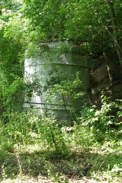
| Vashon Conyers | 3600 North Franklintown Road | January 30, 2018 | 30 | Victim died in well due to trauma to the body | ||
| Ricky Tyrone Williams | 4300 North Franklintown Road | July 15, 2018 | 36 | Shooting victim | ||
| Albertus Nelson | 4700 Franklintown Road | December 07, 2018 | 58 | Shooting victim | ||
| Quante Thompson | 4900 North Franklintown Road | June 08, 2021 | 23 | Victim found with trauma to the body | ||
| Leandrea Sampson | Franklintown Road and Wynans Way | October 24, 2021 | 39 | Female shooting victim found in burning car. Victim lived in Randallstown. Jermaine Jeter(boyfriend) charged. | ||
| Darron McCoy Jr. | Winans Way and Franklintown Road | January 17, 2022 | 23 | Shooting victim. 17 year old boy charged 02/01/22 | ||
| James Moore | 1 Morris Road | January 31, 2022 | 31 | Shooting victim, Ronnie Harris Jr , 33-year-old Janay Barksdale , and 40-year-old Morgan Reed all charged 03/11/22 | ||
| Unidentified Man | 4300 Windsor Mill Drive | September 21, 2022 | 39 |
| ||

If you enjoy Leakin Park or enjoy finding abandoned artifacts in the woods, you may wish to visit my Ghosts of Leakin Park site. If you want to look at a handy trail map for the park you can visit my Leakin Park Trail Map site. General information about 2013 Baltimore City Homicides can be found here.
Update January 6, 2011 I'm getting inquiries from people about murders for years gone by. I have created a helpful tutorial on how the search the Baltimore Sun archives yourself. If you can't find what you are looking for through the Sun Archives you can email me with the approximate date of the murder, the name of the person murdered, the location of the murder and the home address of the murdered person or as much information as you know, and I will see what I can dig up. I am a busy person so you will have to wait patiently for the results.
Special thanks to the Enoch Pratt Free Library and the Charm City Circulator, without their assistance this site wouldn't have been possible. Also I would like to thank Thea Pederson for her attention to detail and good eye.
Share The Bodies of Leakin Park on Facebook


